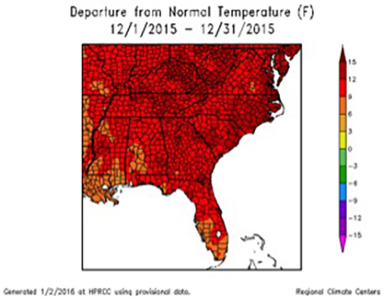
2015 saw one of the warmest Decembers since Georgians started keeping records, and the month was also much wetter than normal.
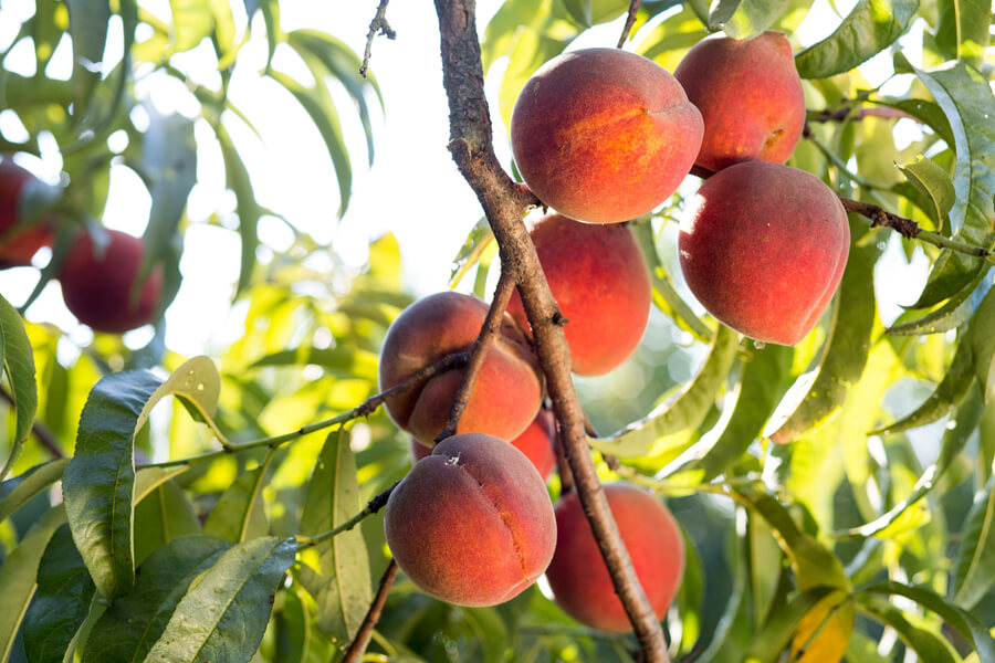
The warm, wet conditions created havoc for Georgia farmers. The wet conditions caused saturation of soils in many places — a big concern for fruit tree farmers since soaked conditions put increased stress on the trees due to a lack of open oxygen pores in the soil. The warm conditions in December caused the lowest number of winter chill hours for fruit-producing trees and bushes in more than a decade, which could reduce the yield of peaches and other fruit in the coming season. These plants require a certain amount of time in the cold between October and February, or “chill hours,” in order to produce fruit.
Many farmers are hopeful that the return of seasonably cool temperatures in January will supply enough chill hours to salvage the state’s fruit-growing season.
Temperatures across Georgia were more than 10 degrees above normal in December 2015 at most weather stations. Numerous daily record temperatures and high minimum temperatures were broken. Most of the records were broken late in the month, from Dec. 24-31, which is unusual for high temperature records. Most of the stations in Georgia recorded their warmest December ever, according to rankings on the Southeast Regional Climate Center’s Perspectives tool.
Savannah, Georgia, broke or tied record highs on seven out of the last eight days of the month, and on many of those days, the high minimum temperature was also broken.
The record warmth can be attributed to the ridge of high pressure that dominated the eastern half of the United States in spite of the cloud cover associated with rainy conditions that blanketed the region, which was under the influence of El Niño. High nighttime low temperatures associated with the cloud cover helped keep the average temperature above normal.
In Atlanta, the monthly average temperature was 57.6 degrees Fahrenheit, 12.3 degrees above normal; in Athens, Georgia, it was 56.4 F, 11 degrees above normal; in Columbus, Georgia, it was 59.1 F, 10 degrees above normal; in Macon, Georgia, it was 58.6 F, 10.6 degrees above normal; in Savannah, Georgia, it was 64.2 F, 12.5 degrees above normal; in Augusta, Georgia, it was 59.3 F, 12.1 degrees above normal; in Albany, Georgia, it was 62.3 F, 11.3 degrees above normal; in Alma, Georgia, it was 63.4 F, 10.8 degrees above normal; in Brunswick, Georgia, it was 64.6 F, 10.5 degrees above normal; in Rome, Georgia, it was 54.0 F, 11.4 degrees above normal; and in Valdosta, Georgia, it was 64.5 F, 11.4 degrees above normal.
Rainy conditions under a persistent storm track that brought heavy rain to many areas covered the northern two-thirds of the state in December, while the stability of the track left southeastern Georgia counties high and dry.
The highest monthly total precipitation recorded by National Weather Service reporting stations was in Columbus at 17.38 inches, 13.11 inches above normal, and the lowest was in Brunswick at 1.35 inches, 1.29 inches below normal.
Atlanta received 12.51 inches, 8.61 inches above normal; Athens received 12.37 inches, 8.64 inches above normal; Augusta received 6.92 inches, 3.53 inches above normal; Macon received 12.62 inches, 8.58 inches above normal; Savannah received 3.35 inches, 0.40 inches above normal; Alma received 1.97 inches, 1.32 inches below normal; Rome received 12.66 inches, 8.28 inches above normal; Valdosta received 6.86 inches, 3.11 inches above normal; and Albany received 2.51 inches, 0.66 inches below normal.
The highest single-day rainfall recorded by Community Collaborative Rain, Hail and Snow Network (CoCoRaHS) volunteers was 8.51 inches recorded near LaGrange, Georgia, in Troup County on Dec. 25, followed by 6.7 inches recorded near Senoia, Georgia, in Coweta County on the same date. The highest monthly total rainfall was 21.94 inches, observed northwest of Ellijay, Georgia, in Gilmer County, followed by 19.41 inches recorded near Dillard, Georgia, in Rabun County and 18.75 inches near Warm Springs, Georgia, in Meriwether County. By comparison, an observer in far southeastern Georgia, near Kingsland, received less than an inch for the entire month.
Severe weather occurred on three days last month. The most notable was a weak EF0 tornado, which blew down numerous trees near Culloden, Georgia, in Monroe and Upson counties on the afternoon of Dec. 24.
The outlook for January and the rest of winter shows a return to more normal wintertime conditions. Cold air is expected to move into the state in the next week and remain through much of the next two months, although daily values will vary. This should be a relief to farmers who need the chill hours to get a good yield for their fruit. El Niño is near its maximum extent but should continue to influence Georgia’s climate for the next few months before it wanes and likely swings to the opposite phase, La Niña, by midsummer, which could lead to dry conditions later in the growing season.
For more information, please see the “Climate and Agriculture in the South East” at blog.extension.uga.edu/climate/. For more on Georgia’s climate visit gaclimate.org. Please feel free to email your weather and climate impacts on agriculture to share on the blog to pknox@uga.edu.